
Predictive Networks: How Baron Weather and GIS are Strengthening Telecom Operations
- Randall René, MBA

- Oct 15, 2025
- 6 min read

When I first started in telecom, I believed the job was simple: keep people connected. Over time, and after years of working through hurricanes, wildfires, and tornado recovery, I learned that connectivity depends on more than towers and cables. It depends on the forces that move around them.
Weather shapes the reliability of every network we build. It decides where service holds steady and where it fails. It determines whether a crew can work safely on a tower or whether a neighborhood loses communication just when it needs it most. Weather is not background noise. It is an active participant in network operations, planning, and safety.
In this post, I’ll explore why weather intelligence is now a cornerstone of modern network management. I’ll share how GIS-integrated weather data from Baron Weather gives service providers the ability to predict, prepare, and protect. I’ll also discuss how this technology supports employee safety, improves customer experiences, and builds lasting resilience into the networks that keep us all connected.
The Growing Impact of Weather on Network Reliability
Telecom networks stretch across coastlines, mountains, forests, and deserts. Every one of those landscapes carries risk. Flooding, heatwaves, ice, and high winds test the limits of infrastructure every single year. The Federal Communications Commission (FCC) has tracked these effects closely. During Hurricane Ida in 2021, for example, nearly 1,000 cell sites across Louisiana and Mississippi went offline due to storm damage and power loss. In some counties, more than half of all towers were down at once.
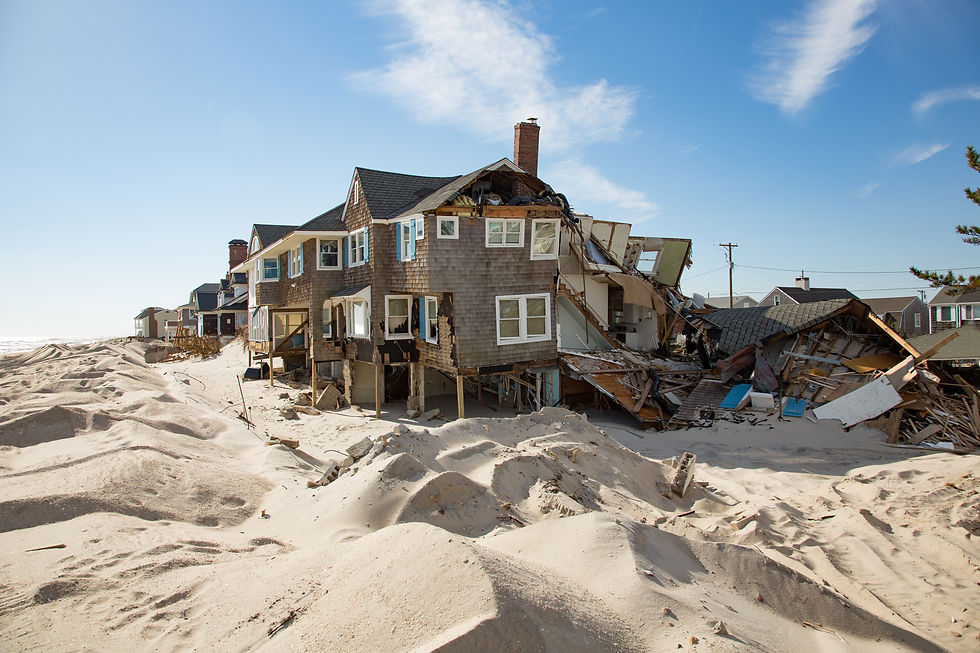
This pattern continues. During Hurricane Milton in 2024, the FCC reported that over 12 percent of cell sites in affected areas of Florida were out of service. That number might sound small, but for the people in those communities, it meant no 911 access, no text alerts, and no contact with family during evacuation and response.
These are not isolated incidents. As extreme weather events grow more frequent, the financial and human impact grows too. Networks that were designed for reliability now need to be redesigned for adaptability. That requires a new kind of intelligence, and it's one that can anticipate risk instead of simply reacting to it.
Beyond Forecasts: Why Location and Timing Matter
Traditional weather forecasts tell you if rain is likely or temperatures will drop. What they do not tell you is how those conditions will impact a specific cell tower, fiber route, or customer cluster. That is where Baron Weather has transformed the field.
Baron integrates radar data, satellite imagery, lightning detection, and sensor networks into predictive models that are layered directly within GIS systems. The result is a living, location-based map of what is happening now and what is expected next.
For network operators, this means seeing not just that a storm is coming, but exactly which tower sites or service areas will experience the highest wind speeds or flooding potential. That level of precision allows companies to make smarter decisions before outages occur.
A Day in the Field: When Alerts Save Lives
Imagine a maintenance crew working on a cell tower miles from town. The morning started calm. Equipment checks were running on schedule. But midafternoon, Baron Weather’s monitoring system detects rotational wind patterns forming in the same county. Within minutes, an automated alert goes out through the company’s GIS dashboard. The coordinates of that specific tower light up in red with a note: “Severe gusts approaching 60 miles per hour in 30 minutes.”
The crew descends and secures their gear. Operations confirms the evacuation. Thirty minutes later, wind speeds spike as predicted. No one is hurt. The tower is stable.

I’ve seen both sides of that story. As a disaster responder, I have stood in storm-torn towns where communication lines were down, emergency services were isolated, and families had no way to reach help. I have also seen what happens when a company has the foresight to act early. It is the difference between risk and readiness. Weather alerts like those provided by Baron Weather are not just operational tools, they are safety systems.
Planning Smarter: Using Weather to Guide Design
The value of weather data extends far beyond day-to-day operations. It also shapes how we design and build networks in the first place.
Picture a broadband expansion project across a mix of rural farmland, forested slopes, and coastal zones. Using GIS, planners can overlay Baron Weather’s climate and hazard data, such as wildfire risk, lightning frequency, precipitation intensity, and flood potential. This layered view reveals where exposure is greatest and where certain design choices could pay off over time.
If a planned route passes through a high wildfire corridor, it may be worth the investment to bury the fiber rather than string it aerially. In flood-prone areas, the reverse might make sense, reducing the risk of water damage and repair delays. These insights turn network design into an informed choice instead of a gamble. Over the long run, those choices protect both infrastructure and people.
Weather Intelligence and the Customer Experience
When storms hit, customers care about one thing: staying connected. They expect their phones, modems, and emergency apps to work, no matter what is happening outside. Service providers that use weather-integrated systems have a clear advantage in meeting that expectation.
Weather sensors placed on towers, antennas, and ground stations feed continuous data into predictive models. These models identify which regions are most likely to experience outages or degraded performance during an event. That information helps operations teams shift network loads, reroute power, and pre-position restoration crews.

After a storm, those same models help prioritize recovery. Instead of waiting for reports from customers or field teams, the system can pinpoint the most affected areas and direct immediate attention there. The outcome is faster restoration, fewer complaints, and a stronger sense of trust between providers and the communities they serve.
Customer experience in telecom has always been about reliability. Weather intelligence is simply the next frontier of reliability, where foresight replaces reaction and where resilience becomes measurable.
Building a Culture of Safety and Resilience
Technology alone cannot make a company resilient. That comes from people, leadership, and culture. Integrating weather data into daily operations means teaching teams to trust the information they receive and to act decisively when alerts occur.
It also means making sure those alerts are transparent. A supervisor should be able to see what triggered a warning, understand the probability of impact, and explain it clearly to their crew. The more visibility people have, the more confidence they gain in the system. Over time, this builds a safety-first culture where decisions are guided by information instead of assumption.
Resilience is not built overnight. It develops when the right data is combined with clear communication, consistent process, and the courage to act early.
Baron Weather and GIS: Turning Awareness into Action
At Waypoint 33, we work with service providers to turn weather awareness into operational strategy. Through our partnership with Baron Weather, we help companies connect predictive weather intelligence directly to their network data.
Our approach begins with understanding the real-world challenges operators face: field safety, restoration times, and service continuity. From there, we build workflows that align Baron Weather’s insights with network operations, asset management, and GIS planning tools.

The result is a system that helps companies anticipate, adapt, and recover more effectively. This partnership bridges technology and experience. It gives decision-makers the clarity they need to prepare for what is coming, protect their people, and serve their communities with confidence.
I’ve seen firsthand how valuable that can be. During disaster recovery operations, connectivity becomes a lifeline. It allows first responders to communicate, families to locate one another, and communities to rebuild faster. Keeping that connection alive is not just a technical challenge, it is a critical responsibility.
Take the Next Step
If your organization is ready to make weather intelligence part of your operational DNA, reach out to learn more. Visit Waypoint33.com to connect with our team and explore how Baron Weather data can integrate into your existing systems.
Together, we can build predictive, proactive, and resilient networks that stand strong through any storm.
Further Reading / References
Federal Communications Commission – Communications Status Report for Areas Impacted by Hurricane Ida (FCC.gov)
Data Center Dynamics – US carriers working to fix network outages caused by Hurricane Milton (DataCenterDynamics.com)
Baron Weather + Waypoint 33 Partner Page – Baron Weather delivers weather intelligence integrated with ArcGIS (waypoint33)


Comments