
Cellular Expert in the United States
Trusted by U.S. carriers, utilities, and public safety agencies
Advanced RF network planning and analysis software, delivered with U.S.-based expertise for telecom, utilities, public safety, government, agriculture, and risk-critical environments.
Waypoint 33 is the U.S. distributor for Cellular Expert, enabling domestic licensing, training, GIS integration, and workflow support.
What Cellular Expert Does
Designed for RF engineers, GIS analysts, and network planners.
Cellular Expert is a suite of RF planning, coverage modeling, and analysis tools built on a powerful GIS foundation. It enables engineers and planners to design, simulate, evaluate, and optimize radio communication systems across a wide range of technologies and environments.
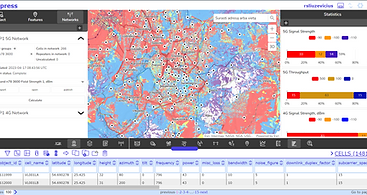
RF Coverage and Propagation Modeling
Use advanced coverage prediction algorithms to model field strength, carrier-to-interference ratios, and best server maps using real-world GIS terrain and land cover data.
Interference, Traffic, and Capacity Insights
Generate interference maps, traffic load estimates, and performance metrics such as SINR and throughput to support network optimization and expansion planning.

Siren Sound Modeling
Use advanced sound propagation algorithms to model siren coverage, public audibility, and reliability using real-world GIS terrain, land cover, and obstacle data.

Radio Link and Backhaul Planning
Plan and evaluate point-to-point and point-to-multipoint microwave and fixed wireless links using path profiling, line-of-sight analysis, and link budget calculations.

GIS-Driven Integration
Integrate radio planning with geographic data to enable constraint-aware network design aligned with infrastructure, demographics, and environmental context.

CE 3D CAD Plug-In
A specialized software component designed to integrate Cellular Expert software with Trimble's SketchUp design & engineering software.

Use Cases by Industry
Cellular Expert supports data driven network planning across diverse operating environments, from dense urban corridors to remote and high risk regions. These industry examples highlight how advanced RF modeling and GIS integration enable reliable connectivity, informed investment decisions, and resilient infrastructure planning.

Telecom and Broadband
Support coverage planning, densification, and optimization across 4G and 5G networks while leveraging spatial context for performance and investment decisions.

Utilities and Energy
Model and plan private wireless networks that support grid operations, field automation, and asset monitoring using GIS-anchored RF insight.

Public Safety
Use detailed signal prediction and coverage analysis to ensure reliable communications for first responders, critical alerts, and resilient emergency systems.

Smart Agriculture
Enable precise network planning across rural and remote areas where automation, sensor connectivity, and low-latency wireless operations depend on predictable coverage.

Disaster Risk Mitigation and
Emergency Warning Systems
Leverage siren and RF propagation modeling for worst-case hazard scenarios such as flooding, tornadoes, and widespread communication interruptions to support resilient public alert systems.

Smart Cities and Transportation
Model wireless coverage and performance across urban infrastructure, transportation corridors, and smart city systems to support connected mobility and public services. Use RF and spatial analysis to evaluate network behavior in dense, highly dynamic environments.
Why Choose Cellular Expert with Waypoint 33
Waypoint 33 works directly with engineering, operations, and planning teams to ensure Cellular Expert is implemented correctly from day one. We provide structured onboarding, technical configuration, workflow integration, and ongoing support to help organizations achieve measurable results quickly.
From initial evaluation through long term operations, our team serves as a trusted technical partner, not just a software reseller.
-
U.S. based licensing and procurement support
-
Deployment and configuration assistance
-
Training for engineers and GIS teams
-
Ongoing optimization and technical advisory